Landscape architecture taught me to read sites.
Computation taught me to interrogate them.
The work between these two is what I'm building a practice around.
Landezing — a deliberate misspelling.
The name starts as a mistake on purpose. I took design, wrote it as wrong as I could make it — desing — and fused that broken word with land. What's left is the practice: landscape, run through computation, named after its own error.
It fits a method I keep noticing in my own work — you learn fastest from how a thing should not be done, then you branch from there, like a tree at a fork in its path, toward how it should. The wrong turn is never wasted. It's the part of the route that tells you which way is right.
The analog discipline.
I trained at Istanbul Technical University, where landscape architecture is taught as a discipline of close reading. You learn to walk a site, sketch its sections, trace its water, name its plants. The tools are slow on purpose — pencil, transect, photo, plan, physical model. For five years, that was the entire toolkit.
The graduation project, Kırkçeşme Historic Park, was the high-water mark of that phase: a 55-kilometer 16th-century water system mapped problem by problem, intervention sited where the analysis pointed. It earned Summa Cum Laude, the ITU Best Graduation Project Award, the UCTEA Equivalent Prize, and the IFLA Europe Young Professionals Award in 2022.
See the Kırkçeşme project →
The inflection year.
2020 was the year three things stacked. I took the **Topography*Topology Grasshopper Workshop at SKAB Architecture — the first time I saw parametric thinking up close. I started a six-month professional internship at the Istanbul Metropolitan Municipality**, where I was mentored by a senior computational designer. And I attended six urban-design symposia in the same calendar year, from Istanbul to Thailand.
What changed wasn't ideology — it was capture. The work shifted from drawing the world to recording it. We scanned a Corinthian column, a pine cone, a public monument, an entire urban park's terrain from a drone. We modeled urban districts block by block from OpenStreetMap data. We sized a parametric solar canopy that fit eighteen cars and 108 m² of photovoltaic surface.
The analog discipline didn't disappear — it deepened. A site analysis that used to be a printed sheet became a multi-layer geospatial model. A hand-traced section became a millimeter-accurate mesh. Same eye for site, scale, and ecology. New instruments.

From pine cone to public park.
The photogrammetric pipeline scales. A pine cone resolves in twenty minutes on an iPhone. A Corinthian column took a tripod and twenty minutes more. A monument, a drone orbit. An entire urban park, hours of flight and overnight processing — but the same fundamental method.
What landscape architecture had treated as fieldwork became data acquisition. The site stopped being something you only visited.


Interactive · drag to rotate
The column itself.


The site, rendered as data.
A public urban park, analyzed at 1:2500. Nine assessment points along a walking route. Seating, activity zones, equipment groups, road indentations — everything classified, located, photographed. The masterplan emerges from the analysis layer, not as a separate creative leap.
The methodology behind this fieldwork later became the foundation of my M.Sc. thesis, ComfortAudio.
See ComfortAudio →Computation as design tool.
A parametric solar canopy sized to an existing 18-car parking lot: 50 meters long, 54 panels at 2×1 m, 108 m² of generation surface. The geometry isn't drawn — it's solved against the site.
Urban districts pulled in directly from OpenStreetMap, parsed by Grasshopper into buildings, streets, and amenities. The city as live geometry, ready for analysis.


A second degree, by choice.
By the end of 2022 the question wasn't whether to keep using computation in landscape work — it was how far to push it. I graduated, took the awards, and chose to enroll in ITU's M.Sc. program in Architectural Design Computing rather than go straight into practice.
It's a program for people who want to be fluent at the tool layer — algorithmic geometry, physics simulation, machine learning, AR pipelines — and use that fluency to design back into architecture and landscape. I'm in the final year, currently at a 3.47 GPA.


Both halves of the workflow.
The work since looks like this. Algorithms I write to control geometry — Miura-Ori fabric-formwork meshes solved by Kangaroo's physics engine. Audio-comfort maps generated from GIS terrain data. AI-trained urban patterns. Photogrammetric models exported to AR Quick Look and embedded directly in the browser.
Plans rendered in Lumion and D5 the same week a parametric script generates the geometry. Same project, both halves of the workflow.
A canvas of nodes.
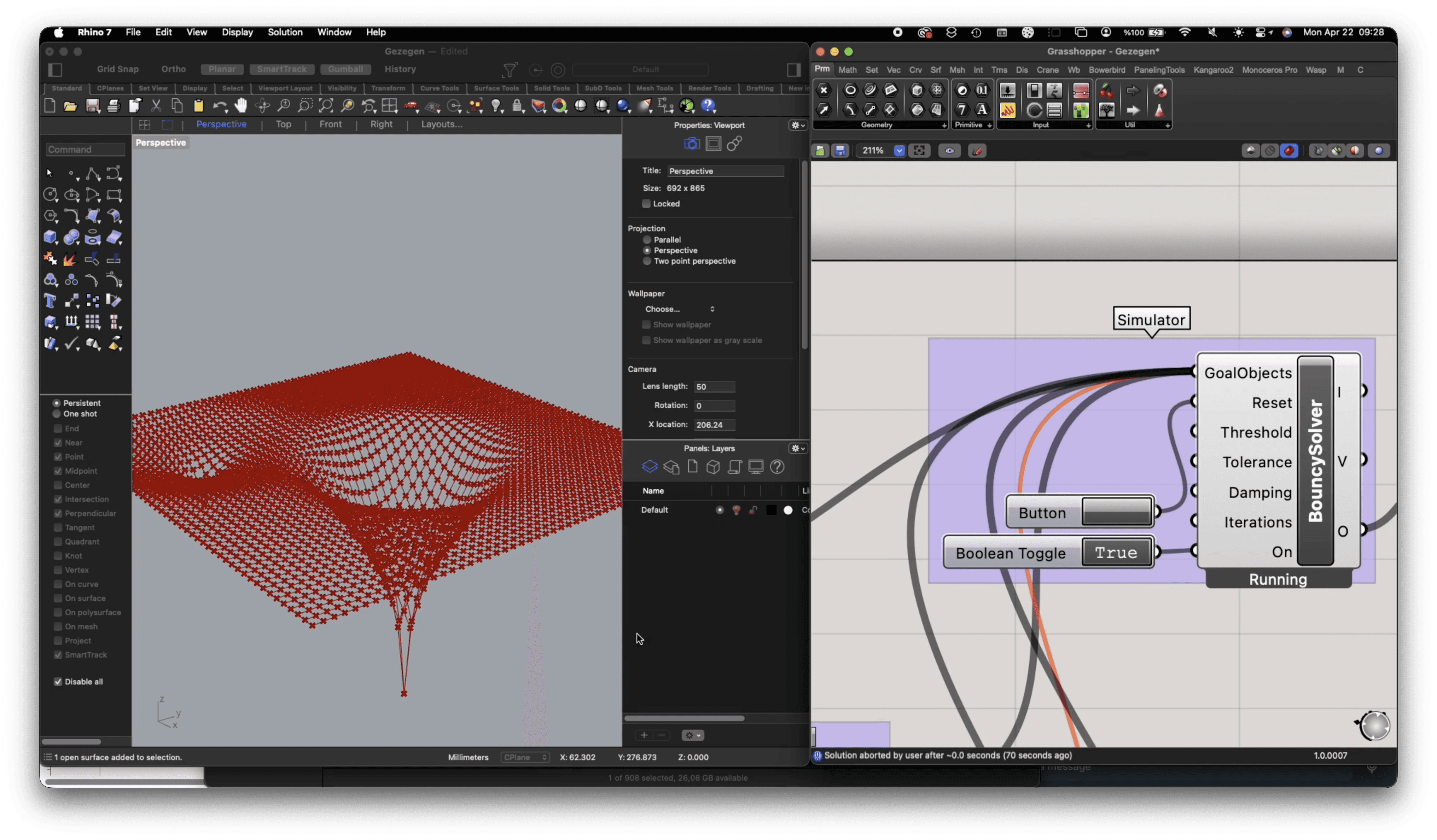
The Miura-Ori fabric-formwork simulation algorithm, built in Grasshopper with the Kangaroo physics solver, plus the simulation running live — a flat mesh sagging into a structurally stable double-curved shell under simulated gravity. The drawing IS the design. Move a slider, the geometry recomputes.
See Miura-Ori →
The drawing becomes a place
The drawings stopped being exercises. Since 2022 I have worked as a landscape architect at the Istanbul Metropolitan Municipality, in the Parks and Green Spaces Directorate — the scale where a decision made on a plan becomes a place people actually walk through.
The computational side turned into research rather than technique: a post at the ITU Virtual Landscape Lab since 2021, and an M.Sc. in Architectural Design Computing whose thesis lands at the end of 2026.
In 2023–24 I spent a year on Lund University's CIPSS programme on behalf of the municipality, developing PlayHub — a tactical-urbanism proposal bringing flexible play to Istanbul's under-served neighbourhoods, tested in one district and across Hatay.
And the teaching started: a 3D modelling workshop for ITU landscape architecture undergraduates, an invited lecture on visual representation, and presenting Kırkçeşme at the university's "Hydrological Networks of the City" session.
What the practice runs on.
Organized by what the tool actually does in the project — not by vendor, not by year.
- LiDAR
- Agisoft Metashape
- Reality Capture
- Apple Object Capture
- Drone (licensed pilot)
What changed wasn't ideology — it was capture.
- Rhinoceros 3D
- Grasshopper
- Kangaroo
- SketchUp
A hand-traced section became a millimeter-accurate mesh.
- Stable Diffusion
- Midjourney
- DALL-E
The geometry isn't drawn — it's solved against the site.
- Lumion
- D5 Render
- V-Ray
- Keyshot
- Twinmotion
- Unreal Engine
Plans rendered in Lumion and D5 the same week a parametric script generates the geometry.
- Apple ARKit
- QGIS
- Figma
- Adobe Suite
This is the deployment edge of the discipline.